
- Shop
- [Blueprint Circuit Map for the 1950 International Sports Car Grand Prix of Watkins Glen]
[Blueprint Circuit Map for the 1950 International Sports Car Grand Prix of Watkins Glen]
[Blueprint Circuit Map for the 1950 International Sports Car Grand Prix of Watkins Glen]
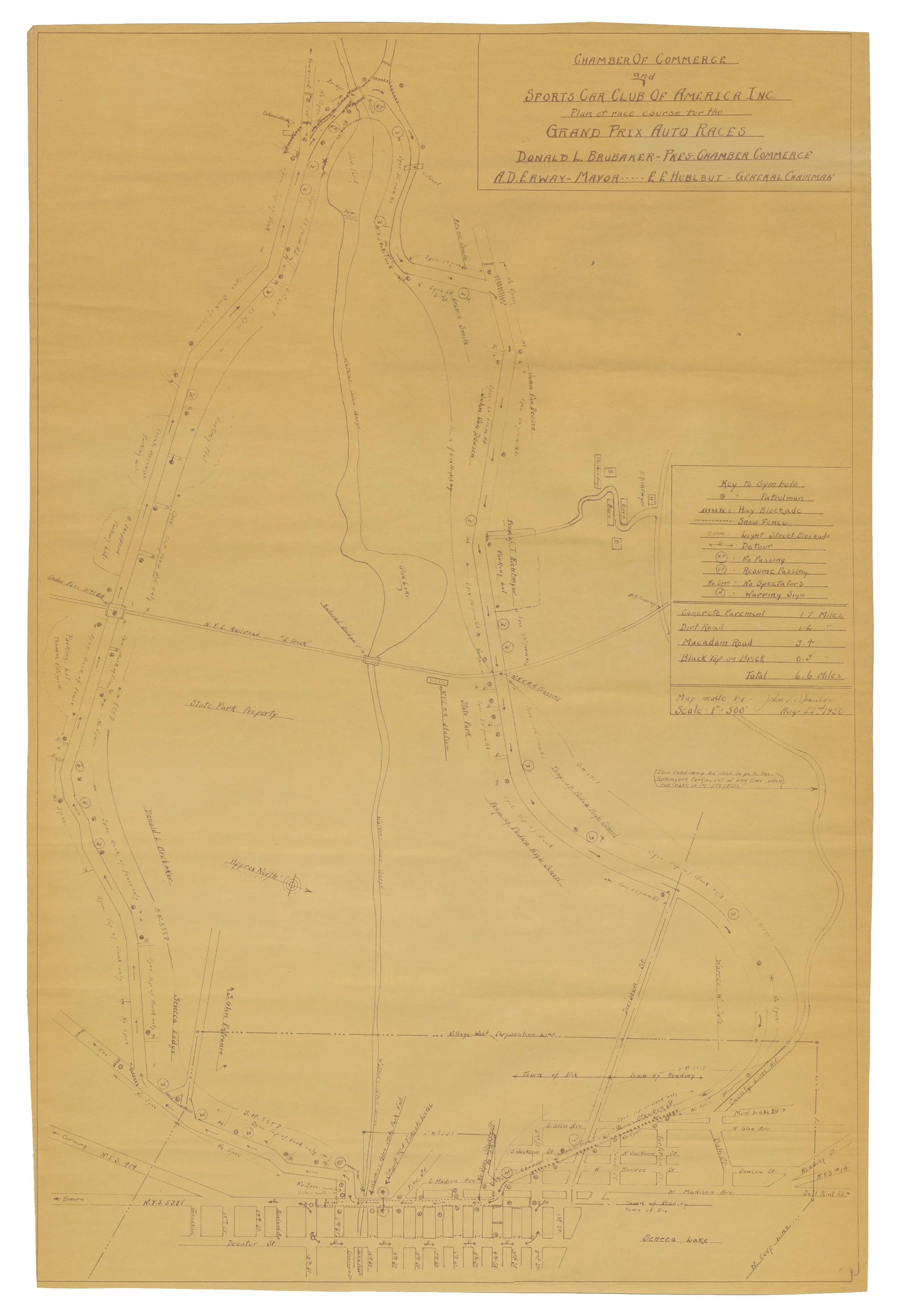
A blueprint map of the proposed track layout for the 1950 International Sports Car Grand Prix of Watkins Glen contested over a circuit consisting of 6.6 miles of local roads and two-lane State Highways around and through the small upstate New York community.
Sanctioned road races in Watkins Glen began in 1948 during the nascent, postwar years of sports car competition in the United States. This 1950 event was the first to receive sanction from the prestigious Federation Internationale de l’Automobile (FIA) and saw an estimated crowd of 100,000 spectators line the circuit to glimpse the finest racing cars and drivers in the world. The event continued as a road race until a tragic accident in the 1952 running saw 12 spectators injured and one killed (a seven year old) when the Allard Mercedes driven by Fred Wacker lost control and went into the crowd. The tragedy brought an abrupt end to road racing in favor of dedicated, closed circuits, not only in Watkins Glen, but in The U.S. in general.
The map appears to have been an internal production meant for the use of race organizers with careful identification of property lines, proposed parking lots and spectator areas, etc… and with a key of symbols noting variant track surfaces (concrete, dirt, macadam, and black top over brick), locations of hay blockades, catch fences, passing and no passing zones, etc…
A closed circuit, Watkins Glen International, was built following the 1952 tragedy which continued the tiny village’s enduring presence on the global auto racing map. It hosted the Formula 1 United States Grand Prix for twenty years between 1961 and 1980 and endures into the present day as a revered venue for club level sports car competition through to the upper echelons of motorsport.
SCANLON, John L. : [Motor Racing] : [Maps]. [Blueprint Circuit Map for the 1950 International Sports Car Grand Prix of Watkins Glen]. [Watkins Glen, New York]: Sports Car Club of America / Watkins Glen Chamber of Commerce, (1950). Approximately 27 1/2" x 18 1/2" diazo print on pale yellow paper stock of an original hand-drawn ink map. Curling from rolled storage, otherwise about near fine.